Showing posts with label Landscapes. Show all posts

Sunday, January 8, 2017

Visiting the Great Wall

Mutianyu Great Wall, China (May 28, 2016)

Flying to China from the US is expensive, especially if one is forced to use american carriers to get travel reimbursement from work. One way to reduce the cost is to relax the constraints on the traveling dates, in order to get the cheapest available flights. It turned out that paying the hotel for one day more after the end of the conference was cheaper than returning the same day. So, I ended up having an extra day to kill in Beijing: perfect occasion to visit a nearby section of the Great Wall.

On the bus to Mutianyau
The Great Wall was built starting from the 7th Century BC, even though little remains of the most ancient parts of its construction. The majority of what survives today is from the Ming Dynasty (1368-1644). The wall was built to control the northern access of China, and to contain the raids from the nomadic hordes living in the northern Mongolia steppes. Overall the actual wall is long more than 6,000 km (almost 4,000 miles), but extends much more if one includes trenches and natural defensive barriers. Most of the Ming Great Wall has now disappeared, a victim of the ravages of time and history. A few sections however have been restored and are now visited by million of tourists every years, many of them Chinese. Visiting the Great Wall is in fact considered a patriotic duty by the Chinese. This may be due to a quote attributed to Chairman Mao: "If you have never been to the Great Wall you are not a real man". Truth is however a little more complicated, as the quote is only the third verse of a poem Mao wrote in 1935 to inspire men and women to complete the Long March:
The heavens are high, the clouds are pale,
We watch as the wild geese disappears southwards,
If we fail to reach the Great Wall we are not true men,
We who have marched more than 20,000 li.
Mutianyau
The isolated sentence may have lost its original meaning, but is nevertheless very effective to promote Chinese tourism to the wall (street vendors offer you a "certificate" if you walk along the wall), especially the Badaling section, the first to be restored in 1975. That section of the wall is the easiest to reach from Beijing, 80 km north of the city and well served by public transportation. It is also the most crowded, so we decided to visit another section, near the fruit producing area of Mutianyau (about the same distance from Beijing than Badaling, but no easy public transportation). Arranging that is not difficult (plenty of travel agencies with english-speaking personnel), as long as you are careful to avoid the "cheap" trip offered by the hotels, which inevitably end with a long stop at a local mall. After some searching we chose to hire a trip with tour-beijing.com, offering "Mutianyau no-shopping tours" for $64 each person (we were 10, so we ended up hiring an entire minivan and private tour guide for that price). The bus picked us up at 8AM, right in front of the hotel, for the 1.5 hours ride to reach the wall (if there is not much traffic, which is instead expected in the morning).

Huge apartment blocks
You can see our guide in the small photo above on the left: she was actually living in the area near Mutianyu and had to leave very early in the morning to pick us up at the hotel. The bus ride was comfortable, but we indeed ended up stuck in highway traffic for half an hour or so. The difficult part was to getting out of the city, an endless expanse of high rise apartment blocks, many of them built surrounding what looked like a factory or assembly plant of sort. One can only appreciate the huge size of Beijing by driving through its never-ending outer suburbs. Once we managed to escape the traffic of the city the flow in the highway became easier, and we drove through a pleasant countryside full of orchards (the area North of Beijing is famous for its fruits production). Until we finally reached the mountains. 

Chairlift to the wall
The wall is a big touristic attraction and its access is well organized. The bus left us at the base of the mountains, where we got a chairlift to the wall, a few hundred meters above (some of us elected to walk on a steep path in the forest). The chairlift (small photo on the right) is actually quite nice, and it affords an unobstructed view of the wall which you cannot have from the wall itself (see large photo above). Once on top, you walk. I will write more extensively of the wall hike on a separate post, but for now I would just remark that even this short restored segment of the wall is actually very long, more than enough to satisfy any wall-walk urging I had, especially considering that any step forward must then be retraced back to the chairlift station, to get back to the bus at the end of the day. Notice however that in the photo on the right the chairs coming down were all empty. That is because the fun way to get back to the base is not with the chairlift, but rather with a very long toboggan.You sit on a small wheeled cart, pull up the brakes and slid all the way down as fast as you trust the centrifugal force to keep you within the banked tracks in the curves (or as fast as the person in front of you). It was indeed quite fun.

Beijing highway (May 28, 2016)

Saturday, September 10, 2016

Grand Marais at Night

Grand Marais, MN (Aug 19, 2016)

Grand Marais is a small center on the shores of Lake Superior, on the Minnesota side. Until the 1920s it could only be reached via boat through the lake. That made the town an important port in the area, thanks to the double bays that offered shelter from the severe storms that hits the area in winter.

Walking at sunset
The original name of the place, the Ojibwe Gichi-Biitoobiig, meant "double water", in reference to these two coves separated by a thin promontory protruding into the lake. A long walkway connects the two harbors, sneaking on the red rock all the way to the lighthouse at the end of the west side cove. A second lighthouse protects the cove from the opposite side. The promontory is now reinforced with a concrete drywall, to protect the fishing port that you can see in the panorama below. A placid mirror of still water bathed in the pink hues of the sunset. The walkway is traced right on top of the seawall, and in some points is just a foot wide. That was not enough for Kero, with his ingrained dislike of water. He panicked and stopped midway, refusing to set one paw more in what he considered a watery trap for his samoyeds instinct. I cannot fault him for that: in the natural environment of samoyeds (Siberian tundra), falling from the ice into liquid water would be a death sentence... So we had to turn back, but not before taking a couple of shots of other tourists walking on the ruby red rocks, or of the lighthouses in the fast approaching darkness.

Grand Marais is not isolated anymore and is now easily reachable driving along the scenic route 61, an hour past the Split Rock Lighthouse. It is a small and livable town, with many excellent restaurants and pubs. We had dinner  at the Harbor House Grille, with Kero that was allowed to stay with us on the nice patio. We got a local fresh fish, that turned out to be just perfect. Well worth the visit.

Grand Marais, MN (Aug 19, 2016)

Wednesday, September 7, 2016

The Split Rock Lighthouse State Park

Split Rock Lighthouse, MN (Aug 19, 2016)

On November 27, 1905, a storm system moved through the Great basin, bringing fresh easterly winds to the Great Lake region. By early morning the next day the winds had reached 68 miles per hour in the harbor of Duluth, Minnesota, on the shores of Lake Superior. It became known as the Mataafa storm, after one of the 29 ships that sank that day. During the storm the water of the lake on the North Shore were raised by almost three feet above normal, and heavy ice and snow covered the region. The temperature were so low that one of the body of the unfortunate sailors from the Maatafa wreck had to be chopped out of solid ice from the bay to be given a proper burial.

Split Rock Lighthouse Park
The portion of the Lake Superior shore where the wrecks occurred was named as the most dangerous coast of the whole Great Lakes region. To prevent a similar tragedy to repeat in future storms, the Pittsburg Shipping Company, owner of many of the lost vessels, lobbied the government to provide some protection in the form of a lighthouse. The Split Rock Lighthouse was built, on a 140-feet rock cliff overlooking Beaver Bay, not far from the site of another shipwrec from that fatal storm, that of the Madeira shooner-barge. With its octagonal shape, steel-frames brick building, it is the most picturesque lighthouse on the Great Lakes. When it was built there were no roads along the North Shore of Lake Superior, and all construction materials had to be supplied by water, and lifted on the cliffs with a crane. Its dramatic location made it a popular touristic attraction for sailors and excursion boats, and in 1924 a road was built from Duluth to allow land access. This was the beginning of Route 61 now connecting all the previously isolated towns on the North Shore, all the way to Grand Marais. Now retired, the lighthouse was added to the National Register of Historic Places in 1969, and designated as National Historic Landmark in 2011.

View from Corundum Point
Since 1945 the lighthouse is part of the Split Rock Lighthouse State park, managed by the Minnesota Department of Natural Resources. We visited the park on our free day during our summer trip to the North Shore. The park is beautifully maintained, with many trails on land, and even a kayak and canoe route along the lake shore. We spent the whole day walking around the park, with Kero leading the way from one pebbly beach to the next (see for example the panorama below). The park has several camping grounds easily accessible from the road; something to consider for the next time we will visit (assuming that Kero would be up for camping... we never tried staying overnight in a tent with him that and I am not sure he would be relaxed enough to actually let us sleep). Before turning back to the cabin we rented, we climbed up a trail leading to Corundum Point, a rocky outcrop raising from the lake with an excellent view on both sides of the shore (little photo above on the right). The point claims its name for the belief that the outcrop was rich of corundum mineral (Al2O3, the same gem as emerald). A crushing house was built high on the lake shore to process the mineral, that however turned out to just be a hard rock, and not the precious gem. One can still see the foundation of the mining buildings along the steep (and sometimes almost lost in the vegetation) trail.

After a quick lunch with some cheese I "smuggled" from Italy, we went back to the car, for a quick stop on the cabin we rented near Lutsen, before heading north to Grand Marais for dinner.

Split Rock Lighthouse Park, MN (Aug 19, 2016)

Saturday, August 27, 2016

The Belt of Venus in the Iron Range

Lutsen, Lake Superior, MN (Aug 18, 2016)

One week ago we drove up all the way to the Minnesota shore of Lake Superior, to spend a couple of days bracing for the beginning of the new semester. After loading Kero and a few supplies in the car we headed to Lutsen, where we found a last minute vacancy in a "Sea Villas" resort on the lake shore.

Belt of Venus
The cabins were very nice, and also quite dog friendly, meaning that Kero got to enjoy the view and had a chance of barking his head off to the waves, when we explored the rocky beach just in front of the porch. The view was indeed nice: all the photos in this post were taken from the grass in front of the porch, just as the sun was setting, and the moon rising on the placid waters of the lake. Do you see the banded sky in all the photos of this post? The blue, then pink, then sunset-colored sky? It is called "belt of Venus", and it is seen in clear skies opposite to the direction of the setting sun. The pink color is due to the light of the sunset scattered back by the fine dust particles high in the Earth's atmosphere. The dark blue zone that separates the pink from the horizon is instead the shadow of Earth projecting in the sky. The red rocks on the shore are not of that color because of the sunset: they are really that red, due to the high content of iron in the mineral in the area. After all, this is part of the Minnesota Iron Range.

You can see some of the cabins in the panorama below. We stayed there two nights, in between two days of driving (Lutsen is a 7.5 hours drive from Ames), with the middle day spent hiking along the lake shore, and having a nice dinner in Gran Marais (but this are stories for the next posts).

Lutsen, Lake Superior, MN (Aug 18, 2016)

Sunday, July 31, 2016

Surfing and Fishing

Muriwai Beach, New Zealand (Jun 6, 2008)

Not us, of course. We didn’t go surfing or fishing at Muriwai beach. We rather walked along the path with our friends watching the surfers and the people fishing on the shore down the cliffs. 

Extreme Rock Fishing
Sports are quite an extreme activity in new Zealand, and this holds true for surfing (the waves are quite strong here, and the cliffs menacing), but even for fishing. It is called “extreme rock fishing” and seems to be very popular at Muriwai beach. The activity consists in fly fishing from rocks battered by the surf. This allows to reach deeper waters (and thus more fish) but entails the risks of being swept away by the waves. Apparently this is the fate of a good number of extreme fishers every year, swallowed by the surf, never to be found again (ok, maybe I am exaggerating, but people do drown this way). We did see some close misses with gigantic waves (the weather was quite stormy as we were there) almost getting some fishers off the flat exposed rocks in the photo on the left. 

When it finally started raining we went back to our friends house (actually to Kendra’s parent house) where we were treated with dinner, and we watched a true kiwi event: a rugby match with the all blacks playing (with the haka and all). The match was against Ireland, and I think they won (we had to leave before the end of the game). I have actually checked on the all blacks official web site and the game was on Jun 7: if true then all dates of this travel diary may be off by one day... oops...

Muriwai Beach, New Zealand (Jun 6, 2008)

Saturday, July 23, 2016

Muriwai Beach

Muriwai Beach, New Zealand (Jun 6, 2008)

Before returning to the US, we made a stop in Auckland, were some friend of us live. Unfortunately, we didn’t have much time to spend there before getting back, but we were able at least to spend a weekend at their place. It was nice, after many years since we last saw each other.

Kendra, Lenya and Greg
We arrived at about dinner time, and we met at the cooperative pre-school where their kids are going (event hough, since we left, the oldest has started primary school). The occasion for meeting there was the celebration of Matariki, the Maori new year, announced by the apparition of the Pleiades in the northern sky. The exact day of the celebration depends on the iwi, but it is in general between June and July. To celebrate, we ate hangi food, cooked to reproduce the traditional Maori way of cooking by hot stones and vapor in a covered pit. The next day we went to Muriwai beach. Despite the very uncertain weather, the place was quite spectacular. The photo above shows weird cliffs with a strange polygonal pattern on top: the little geometrically disposed mounds are gannet nests, now abandoned until the next nesting season. The little photo on the left has our friends Kendra and Greg, with little Lenya carried by her mom (while Tycho and Halen were probably playing on a very vertical sand dune with their grandparents - which are really great people and adopted us while we were there).

Muriwai Beach, New Zealand (Jun 6, 2008)

Saturday, July 2, 2016

Curio Bay and the Niagara Falls Cafe

Curio Bay, New Zealand (Jun 4, 2008)

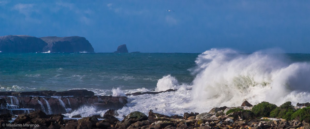
The unpaved road ended at Curio Bay, home of a petrified jurassic forest, a Hector's Dolphin pod, and a yellow eyed penguin colony. We didn’t see any of the above. The sea was so rough that I am quite sure the dolphins were resting in some quieter waters and the penguins were getting their fix of fishes far from the crashing waves. What about the forest? Well, the forest is in the photo above... just submerged. It is best visible at low tide, and we clearly didn’t time it right. The view of the bay was however quite spectacular and worth the stop, with some of the most amazing surf I have ever seen (and heard, the thunder of the waves breaking on the rocks is quite deafening). The spray can get very high, as you can see in the photo below, taken from the top of the cliffs. Below the cliffs there is a beach, were occasionally sea lions can be found (nope, we didn’t see them either). The place was in fact completely empty, I imagine because of the low season and the foul sea. The shores of the Catlins are famous for their numerous ship wrecks: with these waves it is not difficult to understand why.

Curio Bay
In the middle of the Catlins there are diminutive falls that somebody with sense of humor called “Niagara Falls”. We didn’t see the falls, nor the town with the same name, but we did stop in the neighborhood. It was already past lunch time and the town of Niagara was the first settlement we had passed in several hours. We stopped at a nice wooden construction along the Niagara-Waikawa road, with a large “Niagara Falls Cafe and Art Gallery” sign in the front. The entrance is through the art gallery, which we didn’t have much time to explore. The cafe proper is in a luminous room facing a large patio which was closed, due to the cold weather. In the large garden, a goat with a stick stuck on her horns (to prevent her to stick her head in the fence, which apparently she had enjoyed one too many times). On the wall there was a newspaper cutout with the story of the cafe. The owner was a nice New Zealand-born lady that until a few years before was a high level manager of some company in Australia. She got sick of the rat-race, came back home, found an old run-down school building in the middle of the Catlins and converted it into a cafe. The location may seem a little isolated (it was the only place we found in hours of driving), but that same isolation, along a road that is traveled by massive amount of tourists in summer, must be a boon for the business. Deserved business that is, as the sandwiches we got were quite good, the cafe was excellent, and the cake topped with ice cream was even better. 

Restored, we left the cafe directed to our last Catlins stop: Nugget point and its penguin colony. But that is a story for the next post.

Curio Bay, New Zealand (Jun 4, 2008)

Sunday, June 12, 2016

The Catlins

The Catlins, New Zealand (Jun 4, 2008)


For the last full day of our trip in the South Island we had on our plate the crossing of the Catlins. This is a region at the southern tip of New Zealand, between Invercagill and Balclutha, with a spectacular coastline and a dense temperate rainforest. The area had been inhabited by the Maori for more than 1,000 years. The modern name of the Catlins, however, is from Captain Edward Cattlin, who bought a large piece of land on 15 February 1840 from Kāi Tahu chief Hone Tuhawaiki for muskets and £30 (roughly NZ$3000 in 2005 dollars). The land commissioner declined to endorse the purchase, and most of the land was then returned to the Maori after Cattling death, but the name stuck.

The Catlins
We left Te Anau early in the morning on Route 94, turning South at Gore to reach the “Catlin Highway”. I am putting quotes here, because this part of the Southern Scenic Route is no longer designated as a the State Highway 92. It is instead a collection of roads of different size, some of them not fully paved, many of them quite scenic. We were in a hurry, so we couldn’t stop much along the way, but the little roads of the Catlins are certainly worth spending some slow time, looking at the local fauna and at the landscape. We took one of these little roads, passing through the costal hills of the Catlins. The photo on the left shows one of the many ponds along the way, with the usual complements of sheep and aquatic birds (this time, uncharacteristically, swans). The photo above was instead farther down the way, I believe along the Haldane-Curio bay road, an unpaved road that leisurely crosses the southern part of the Catlins. The road ended up in Curio bay, but I will leave that for next post.

The Catlins, New Zealand (Jun 4, 2008)

Saturday, May 14, 2016

Milford Deep

Milford Sound, New Zealand (Jun 3, 2008)

The fishes in the small photo below are Butterfly Perches, which are one of the many species living in the waters of Milford Sound. The white “branch” in the background is instead the very rare black coral (which is actually white, or bright colored, the black moniker due to the color of its skeleton). Black corals live only at great depths, but in Milford Sound can be found closer to the surface because of the unusual darkness of its waters. The steep walls of the mountains in the fiord are rich in vegetation, but lack soil. As a consequence, the rain washes all organic matters directly in the sound, which is rich of tannin. That makes the water very dark, and allows the growth of the black coral.

Butterfly perches and black coral
The photo was not taken in an aquarium, nor we did scuba diving. We would have liked to (we even brought our masks along, but time (lack of) and a persistent congestion prevented that. Plus the New Zealand seas are quite cold all year round, and we were in winter. We however did see the marine life of Milford Sound in its natural setting. The Milford Discovery Center and Underwater Observatory is a floating cylinder of concrete that is immersed over 10 meters deep in the sound. From its windows 12 cm thick it is possible to see the wildlife as you would see it from the window of a submarine. The observatory (which is built like a floating “tank” and as such doesn’t have any ecological impact on the fragile ecosystem of the sound) is exactly the opposite of an aquarium: the wildlife outside the window is completely free, its the people that are stuck in a “air” tank.

Milford Sound, New Zealand (Jun 3, 2008)


Saturday, April 30, 2016

Disaster!

Milford Sound, New Zealand (Jun 3, 2008)

How many memory cards do you have for your camera while traveling?


...


We went on the boat tour with some friends that were also traveling in New Zealand and happened to be directed to Milford Sound the same day as us (ok, it was not by chance, we exchanged a couple of text messages to make that happen). Despite being very cold, we decided to do the tour on the open deck of the boat, because the sun was so bright that it would have been a shame to stay inside. Besides, I came all the way to New Zealand to take pictures, right?


So we were, the four of us, on the bow of the vessel navigating the placid waters of the sound. The sound (which is quite deep) is protected by the strong currents of the Tasman sea by a shallower entrance, corresponding to the terminal moraine left by the glacier that 10,000 years ago created the fiord. The entrance to the sound is in fact so narrow that captain Cook missed it, when in 1769 he circumnavigated New Zealand during its first voyage. The scenery is so beautiful that I kept shooting non stop from the deck of the boat, and by the time we arrived at the entrance of the sound I had filled my memory card and was time to change it with a new one.


Tasmanian Sea
As I was kneeling to my backpack to get the new card, I half heard the captain saying to hold tight because we were about to enter the Tasman sea, famous for its currents. I guess at that point he advised everybody to get back inside because the sea was going to get rough. Well, as soon as he finished talking, while I was still with the old card in my mouth, the new one in one hand and the camera in the other, a gigantic wave hit the boat. I was launched towards the sky (fortunately I fell back in the boat) while the wave washed the deck through the hole of the anchor, drenching everybody still on the deck. As you can imagine I was a little startled, but seeing some photo opportunities (see photo on the left) I just put the card in the camera, deleted whatever old images were on it, and prepared to shoot again. Well... here is the problem. In the confusion I put back the card I had just filled with all the photos of Route 94 and Milford sound, and then deleted all of them. All 100 photos of the day: gone.

That’s why I asked how many cards do you bring along with you. I usually prefer more smaller cards, so that if anything happens to one of them, I still have the others. Still that can lead to accidents like this one if you are not very careful (or if you are distracted by almost getting thrown overboard). So, there I was, wet, without photos, kind of upset... tempted to launch the damn card overboard once for all... and I would have probably done that if Mayli hadn’t forced me to calm down and hand her over the card for safe-keeping.


When we went back to the Motel, we managed to get internet to see if anything could be done. After a quick search with Google, find out that Lexar (the manufacturer of my cards) sells a program, Image Rescue, capable to recover photos that have been accidentally deleted, as long as they are not overwritten by new ones. Apparently I am not the only bozo deleting photos by mistake. The program really worked well, and I was able to recover 95 of the 100 photos I thought were irrecoverably lost. Definitely $30 well spent. Now I keep a copy of the software on each of my memory cards (in the directory that is not cleared when the photos are deleted)... just in case...

Milford Sound, New Zealand (Jun 3, 2008)

Wednesday, April 13, 2016

The Road to Milford Sound

Eglinton Valley, New Zealand (Jun 3, 2008)

We woke up in the coldest morning since our arrival in New Zealand. As we moved South, and more into the winter, the temperature had been falling, but this was the first time we found the car completely covered by a thick layer of frost. We set up to leave as early as possible because the destination of the day was Milford Sound. Piopiotahi in Maori (after the now extinct piopio bird), it is probably the most famous touristic destination of New Zealand. So famous that, during Summer, its single access road is completely congested with the traffic of 500,000 tourists each year.

Along the Road to Milford Sound
Being Winter, it wasn’t that bad, and in fact we were often the only car on the road. Route 94, the “Te Anau - Milford Highway”, is actually a nice single lane road, that covers the 121 km between Te Anau and the Sound along the Eglinton and Hollyford Rivers to the East and the Cleddau to the West. The road was opened only in 1953, when the 1270 m long Homer Tunnel was completed. The tunnel crosses the highest point in the route, at almost 1000 m of elevation. Not too much in absolute terms, but the mountains on the side of the road are still quite impressive (see photo below). In winter the road is often closed due to avalanches. Before Route 94 was completed, Milford Sound was only accessible from the sea, or by a 4 day hike along the Milford Track. The track has been defined as “The Finest Walk in the World” by New Zealand poet Blanche Baughan, and the name stuck. Due to our lack of training and time, we could not walk along the track, which must be quite a spectacular experience.

Even the road, however, was spectacular, and more so in this cold winter morning, with few cars and a crystal clear sky. The large photo above, one of my favorite of the entire trip, shows the Eglinton Valley: fiery mountains covered with snow, mist slowly dissipating with the first rays of the sun, and the glossy frost covering the dry grass and the naked bushes.


View near the entrance to Homer Tunnel, New Zealand (Jun 3, 2008)

Saturday, February 20, 2016

Lake Wanaka

Lake Wanaka, New Zealand (June 2, 2008)


Driving South from Makaroa, we entered the Otago region. As we were driving deeper in the rugged mountains that where the theatre of a late gold rush in 1860, the road entered in wide U shaped glacial valleys filled with large lakes. Lake Wanaka appeared below us as a long strip of water, that clearly filled the void left by a retiring glacier, more similar to a fiord than a lake.


Lake Wanaka
I took several panoramic of the lake (see one below), from view points easily accessible on the side of the road, and them from a great camping ground on its shore. Again, I think being in Winter was a plus, as the snow on the mountains reflecting on the lake made the view even more spectacular.  At the end of the lake there is the town of, unsurprisingly, Wanaka. Wanaka is a popular touristic destination and we stopped there to get a sandwich for lunch at a cafe on the lake shorefront. The view from that same shorefront has provided an unlikely backdrop for one of the most spectacular scenes of that movie I often cite here. Do you remember the mad ride of Gandalf when he was going to Minas Tirith on his white horse? Well, the mountains rising at the horizon are the same mountains visible from the shore of the lake in downtown Wanaka, with the lake water digitally replaced with the tall green grass!

Lake Wanaka, New Zealand (June 2, 2008)


Friday, February 12, 2016

From Jackson Bay to Makarora

Jackson Bay, New Zealand (June 1, 2008)


The view at Jackson Bay, and on the road to get there, was certainly worth the drive (and the skipped lunch). The original reason we went there, however, was for the chance of getting to see the local colony of penguins. The timing was wrong, though, as penguins spend the day out at sea, fishing. We still saw other interesting birds, like the cormorant in the photo (maybe a Little Pied Cormorant?), quite upset that I bothered him with my camera, during its afternoon rest on the Jackson Bay pier.

The Milky Way

As it was getting late, once we got back to the main road at Haast, we went to the visitor office (an impressive concrete “cathedral” a little out of place in the very small village) to see if we could reserve a place for the night further along the road. Apparently they couldn’t do it, and they didn’t know where we could get food either, so we just decided to take our chances and keep driving. At sunset we finally reached Makarora, a tiny village surrounded by the Mount Aspiring National Park. We stopped at the Makarora Wilderness Resort. The resort was a nice surprise. Being out of season it was almost empty, and we got one of their cozy chalet for the night, for a cheaper price than expected. And then, best of all, we got our fish and chips, prepared by the custodian of the place, even though the restaurant was closed (due to the Queen's Birthday the next day). Fish was good, crankiness gone, a lively fire was burning in the fireplace... what more could we desire for the day? Well, as we were walking back to the chalet we looked up, to discover, for the first time since we were in New Zealand, a totally cloudless dark sky, with an impossibly bright Milky Way cutting through it (the Milky Way is much brighter seen from the Southern Hemisphere, from where the Bulge of our Galaxy is visible), and the Magellanic Clouds in all their glory. A perfect way of ending the day!

Mount Aspiring National Park, New Zealand (June 1, 2008)

Saturday, February 6, 2016

Jackson Bay and the Craypot Cafe

Jackson Bay, New Zealand (June 1, 2008)


Remember the nice retired couple that asked me about my Nikon at Arthur’s pass? Well, before they left they told me that one place we have absolutely to visit on our way to Fiordland was Jackson Bay. It is easy to find, they said, just follow the road along the coast until it ends... and then keep going: you cannot be mistaken, once you reach the bay there is no other place to go. And to make sure I would remember the name, they wrote it on the first piece of paper they could find, which turned out to be a mint new check, barely remembering to void it at the last minute. As I have said many times in this diary: New Zealand people are just plain nice, and they don’t seem to have lost the trust in other human beings that is so rare in many other parts of the “civilized” world.


Jackson Bay
And to Jackson Bay we went. The road is very scenic. It starts before Route 6 turns inland towards Haast Pass, more or less at Haast Beach, and continues along the coast until it crosses the impressive Arawhata River Valley. Due to ours numerous stops along Route 6 (including Lake Matheson, Bruce Bay, Shop Creek...) it was getting very late for lunch, and we were starving as breakfast in Fox Glacier was only a remote memory. We where however comforted by the billboards we saw, from time to time along the solitary road, of the Craypot Cafe serving fish & Chips in Jackson Bay. When we arrived at the bay the view was really magnificent, with the white capped mountains reflected in the most placid bay, shielded by the currents of the Tasman sea by the Jackson Head on its westernmost side. A long wood pontoon is the main structure in the village, which doesn’t have many other constructions apart for some fishermen houses, and of course the Craypot Cafe. I found on the internet that the owner of the cafe is called Meg. In her own words, as narrated by Allan Dick of NZ Today Magazine: “My kids were in Queenstown, I moved to Wanaka and came through here one day and just loved the place and stayed. That was 12 years ago. - Meg’s owned the Craypot Cafe for just one summer season. - It’s been busy. It’s seven days a week and I’m looking forward to closing for winter and going somewhere for a holiday — probably the islands...”.

Uh oh...

Did you read with attention? “I’m looking forward to closing for winter and going somewhere for a holiday” she said. And read the date of the photo above: June, which is Winter! There it goes, our fish and chips: Meg was somewhere vacationing in the islands, whatever islands she meant, while we where in that beautiful, but deserted, village at the very end of the last road, with an empty stomach and nothing to eat! Oh Meggie, Meggie what have we done?

Jackson Bay, New Zealand (June 1, 2008)